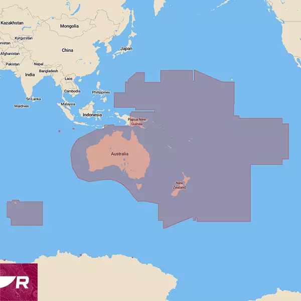
Preloaded microSD card with coverage for entire shoreline of Australia, Tasmania, Melville, Kangaroo, Christmas Island and Cocus (Keeling) + 8,000 islands, New Zealand + 600 islands, South Pacific Islands, Papua New Guinea, Solomon Islands, New Caledonia, Vanuatu, and Timor-Leste.

Take command of surrounding waters with LightHouse Charts Australia and New Zealand. Discover visually stunning, customizable marine charts with color-shaded depth contours, data-rich points of interest and superior clarity that only Raymarine can provide.
Coverage:
Entire Australian Coastal Shoreline is covered. Tasmania, Melville, Kangaroo, Christmas Island and Cocus (Keeling) and over 8,000 other islands included. Detailed intercoastal areas of Gold Coast, Gosford, Melbourne, Sydney, Gippsland Lakes, and many more. Rivers covered include Brisbane, Brunswick, Clarence, Hawkesbury, Richmond, Swan, Tweed, and many more. New Zealand coastal Shoreline and more than 600 islands covered. Papua New Guinea, Solomon Islands, New Caledonia, Vanuatu, and Timor-Leste are covered in the chart. South Pacific Islands are included. Tides and currents information are available planning and safety. Point of interest data included from Marinas.com with subscription.
Compatibility:
Raymarine Axiom, Axiom+, Axiom Pro, Axiom XL, and Raymarine Element.
Includes 1 Free year of LightHouse Charts Premium Subscription
The LightHouse Charts Manager is the portal to download LightHouse Charts and manage your LightHouse Charts Premium subscription. Use the LightHouse Charts manager to add Points of Interests / Premium Content to your selected regions - for both blank microSD cards and preloaded LightHouse microSD cards. Watch the video to learn how to download your charts and add POI to your selected regions.
Visit the LightHouse Charts Manager


